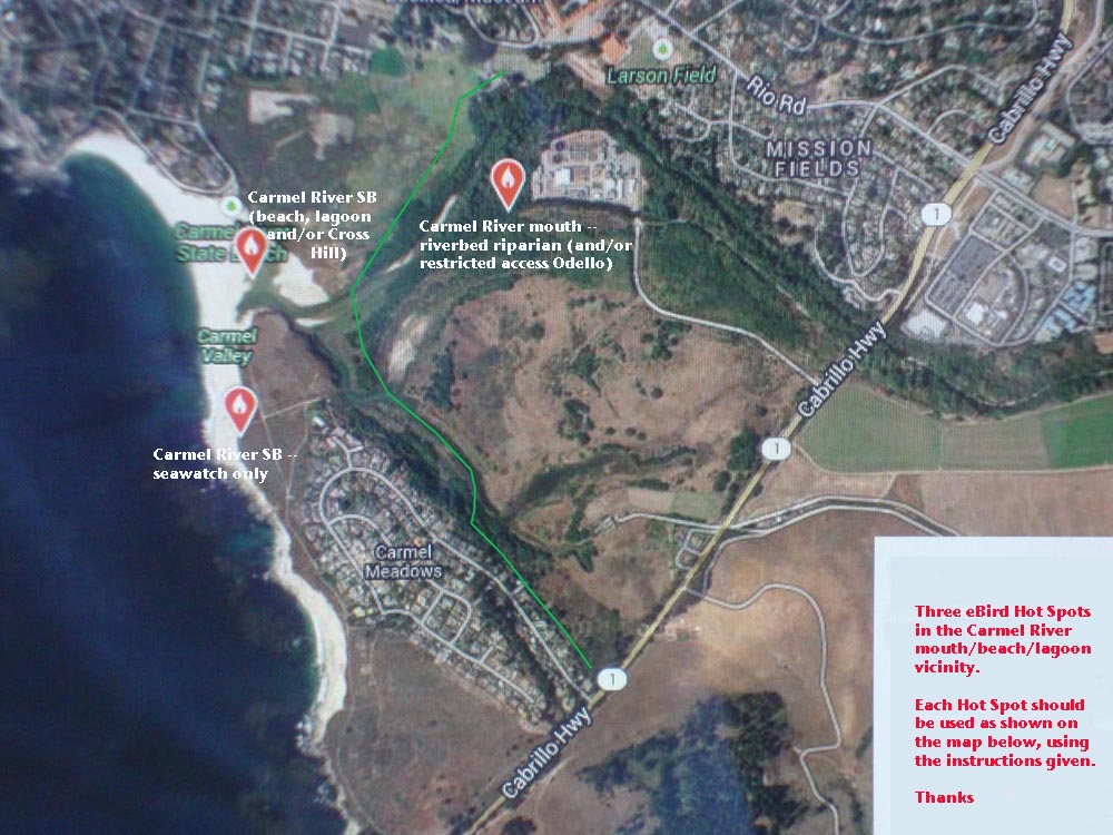
eBirding Carmel River mouth
eBird has three (3) Hot Spots within the "Carmel River mouth" listing
area. Some land is public, some is private (no access), and the
restoration area called "Odello," which includes the recently created
"Odello lagoon," is a restricted access area. It may be entered only by
a few long-time volunteers via permits.
This satellite view (below) shows the entire area (essentially west of Highway and south of the Carmel River bridge,
with the 3 named Hot Spots
|
|
Here's a quick overview of the three eBird Hot spots:
- Carmel
River SB (beach, lagoon and/or Cross Hill). There are two ways to reach
this public beach. From the north, through the City of Carmel, take
Santa Lucia Ave. west from Rio Road to Carmelo St., turn left (south)
and drive to the State Beach parking lot. Here the public has access to
the lagoon, a wide sandy beach, a marsh to the east of the lagoon, and
when the river is running through to the Pacific Ocean, the actual
point where the river meets the sea. Alternatively, from Hwy 1, take
Ribera Road north into the Carmel Meadows subdivision, continue north
to Calle la Cruz, and turn right to the end of this dead-end road. Park
here, go around the gate and take the wide paved road downhill to the
State Park. Here there are dirt paths through coastal scrub to the
beach and to the lagoon, or up to the top of a little hill with a big
cross on it. Birders call this "Cross Hill." From the top one can view
the lagoon to the north, and to the east and south see portions of the
newly created "Odello Lagoon."
- Carmel River
SB--seawatch only. This is a subset of the Carmel River SB hot spot.
You can seawatch from the edge low cliffs overlooking the beach and
scope into Carmel Bay towards Pt. Lobos. If you do some seawatching as
part of a trip that also checks Carmel Lagoon and/or Cross Hill — use
the preceding more general Hot Spot. However, if your visit is simply
to seawatch and not check other sites (such as in stormy or very windy
weather), then you may use this hot spot to enter your focused
sea-watch into eBird.
- Carmel River mouth —
riverbed riparian (and/or restricted access Odello Lagoon). This hot
spot has two elements but they blend into each other. There is public
access to the riverbed of the Carmel River — reached by taking trails
under the Hwy 1 bridge and into the riverbed. Then there is a
restoration site ("Odello") that is not open to the public. Let's look
in more detail:
- Riparian
riverbed — from its discovery in the 1950s, this was one of the premium
vagrant spots in all of California, and was rivaled only by Pt. Pinos
as the best vagrant spot in Monterey County from the 1960s to about the
end of the 1990s. Many rare eastern vagrants have been found in the
riparian habitat lining the Carmel River, mostly in fall but sometimes
in winter or spring. Before the turn of the 21st century, the riverbed
was dry in fall migration, so birders could walk for a mile on a sandy
riverbed, past a "green pipe" that crosses the river to the Wastewater
Treatment Plant, and continue to the edge of the Carmel Lagoon itself.
The lagoon always had water but the riverbed did not except after the
winter rains. So it was a great birding area in the autumn. This
changed with State orders to release water from upstream dams, and to
reduce groundwater pumping to provide fall habitat for the endangered
run of Carmel River steelhead trout. Now the riverbed always has some
water — it is drier in the fall during droughts, but still has deep
puddles. It now requires rubber boots or getting wet to bird the
riparian edges of the river in autumn. Vagrants are still found here in
the public access areas, but the physical difficulty of dealing with
wading in the river calf-deep or so presents problems. There is much
less coverage now than there was in the 20th century. [There has always
been a problem here with hobos and 'homeless' as well. They are usually
harmless but many birders prefer to go here in groups.]
- "Odello
restoration area" — until the floods of 1995, the area south of the
river and west of Hwy 1 was an agricultural field used by the Odello
family to grow artichokes. It was off-limits to birders. After the 1995
flood it was acquired by the State of California as a flood overflow
area, and is now managed by State Parks for habitat restoration. A
multi-armed lagoon was dredged and connected to the Carmel Lagoon in a
channel just east of Cross Hill. This new "Odello Lagoon" is managed
for steelhead — sometimes the lagoon is very full, and at other times
the 'arms' are empty. Willows are naturally reclaiming part of the
area, and others have been planted. State Parks has limited access to
only those with permits, and the permits themselves are limited to
local volunteers only who collect data there.
- Wastewater
Treatment Plant (WTP) — in the 1960s this location was open to birders,
but the system for treating wastewater has dramatically changed here.
There are no longer any open ponds. The entire WTP is now fenced and
blocked by a gate. There is absolutely no access here.
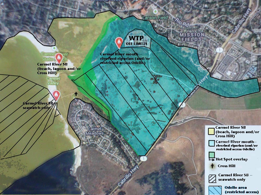
The
map below shows how the 3 Hot Spots are to be used. Review the washes
of color and other information on this map. Further details follow the
map.
|
|
For purposes of using eBird, please use this map and these instructions:
- Carmel
River SB (beach, lagoon and/or Cross Hill) — this is the yellow wash
(actually looks yellow-brown in the overlay), and includes the beach,
Carmel Lagoon, the marsh east of Lagoon, and any viewing out over
Carmel Bay that you may do as part of a visit that checks these
different sites. Cross Hill is marked with a black cross. Many birders
go up here and look all directions. See the green area to the east of
Cross Hill. This is actually within the Carmel River mouth Hot Spot,
but you may include birds seen within the green "overlap" area within
your Carmel River SB visit.
- Carmel River
mouth (riverbed riparian and/or Odello) — all the access points for
this Hot Spot are different than Carmel River SB, so you will know when
you are within this Hot Spot. You will either be in the riverbed
(probably in rubber boots) or you will be entering an old checklist
from the 1970s, '80s, or '90s. Or you may have one of the few access
permits to Odello, and already know your way around. There are no good
places to see Carmel Lagoon from within the Carmel River mouth hot spot
— unless you wade all the way to the lagoon — so please don't include
the gull or tern flocks in the lagoon within your Carmel River mouth
list. Obviously you can't see the ocean from anywhere in the hot spot,
so don't enter seabirds on Carmel Bay in this hot spot. You may,
however, includes birds on the southwest side of the Odello Lagoons
that you can see or hear from the northeast side, and these will all be
within the green "overlap" zone shown on the map. [The Wastewater
Treatment Plant is off limits to entry, but count birds within that you
see or hear from outside.]
- Carmel River
SB--seawatch only — this is meant to be used ONLY as a stationary count
when you are scoping out over Carmel Bay. You will primarily be seeing
loons, grebes, scoters, shearwaters, gulls, and alcids. Feel free to
add any shorebirds along the beach, or anything you hear from behind
you as you are scoping the Bay. But if you do some active birding along
the beach, or in the paths through the coastal scrub, please either (a)
do another checklist with these species called Carmel River SB, or (b)
don't include them on your "seawatch."
|
|