| |
To
understand the boundaries that birders use as county lines offshore, it
helps to understand the concepts of sovereignty (a nation's supreme
power within its borders) and jurisdiction (right of a legal or
political agency to exercise its authority over a person, subject
matter, or territory). In the United States there are four distinct
zones to which jurisdiction (in a formal legal sense) applies:
- The
FIRST ZONE is for formal county jurisdiction (e.g., the county sheriff
can arrest you). In California, these county boundaries are described
in excruciating detail in the California Government Code, including any
islands offshore that are within that county. All coastal counties
include a portion of the Pacific Ocean out to three nautical miles [or
more when a "closed bay" is involved, see below].
- The
SECOND ZONE is official state jurisdiction (e.g., Calif. Fish &
Game officers can arrest you). Because the State of California
exercises its authority through the county court system, the borders of
California incorporate all the land and offshore waters that are
attributed to the 58 counties in the Government Code.
- The
THIRD ZONE is a zone of official United States sovereignty (the FBI can
arrest you). Under international law this is 12 nautical miles from the
nearest point of land (including islands; sometimes farther when
"closed bays" are involved). Under international law, a nation
exercises complete power over this 12 nmi zone and can exclude ships or
persons from other nations.
- The FOURTH ZONE is
the zone of internationally recognized jurisdiction — the
"Exclusive Economic Zone" or EEZ — over sea-bed and fisheries
resources. Although any nation's ship can transit the waters under the
doctrine of "freedom of the seas, the nation with EEZ jurisdiction may
regulate fishing, seabed mining, oil drilling, etc. This jurisdiction
is 200 nautical miles from the nearest point of land, including islands
(see footnote 1).
|
Birding boundaries:
on land, birders use the official boundaries of nations, states, and
counties — in California, the latter are in the Government Code
and appear on all good maps. Offshore, birders use the boundaries of
the Exclusive Economic Zone [EEZ] to extend national, state, and county
boundaries out to 200 nmi [nautical miles; see footnote 2]. The outer
EEZ boundaries appear on many good nautical maps and have been
officially adopted by the AOU and SACC, among others. In practice,
since the Government Code describes the limits of the first 3 nmi
offshore, those limits are applied to county lines near-shore. Beyond
the 3-mile-limit, birders worldwide have adopted the "nearest point of
land" protocol to determine county limits between 3 nmi to 200 nmi
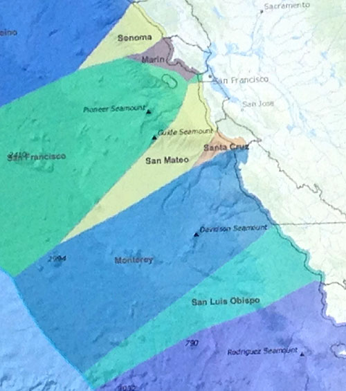
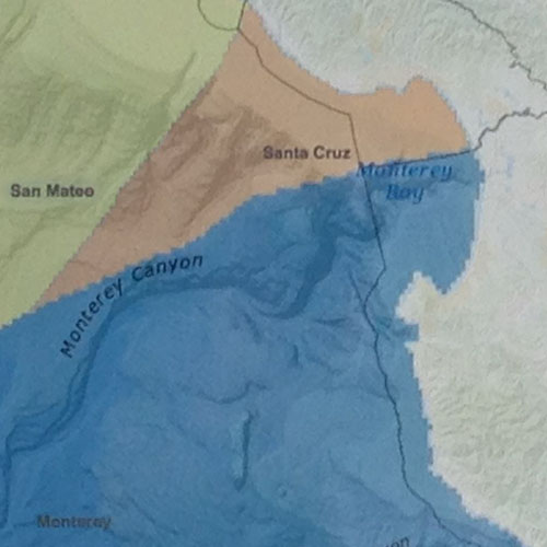
offshore. An excellent map showing these county limits at sea is on Kurt Radamaker's website. This map (right), from that website, shows the county limits at sea as applied to the central coast of California.
Because
islands — such as the Farallones — and prominent coastal
headlands — Pt. Reyes, Pt. Sur, Pt. Conception — dominate
when applying the "nearest point of land" far offshore, some counties
have large slices of ocean offshore and others have very small slices.
And again, these boundaries on the map at right only reflect the
situation between the 3-nmi-limit and 200 nmi limit.
In
the Monterey Bay area we rarely get more than 30 miles west of Pt.
Pinos, so the bigger problem is determining the county boundaries
within Monterey Bay. Let's turn our attention to that topic. |
|
|
|
The problem of "closed bays"
The
existence of "closed bays" provides an exception to the rule that
coastal counties run offshore for 3 nmi. San Francisco Bay is a classic
"closed bay." It is a huge bay but very narrow at its mouth to the sea.
Today the Golden Gate Bridge crosses close to the narrowest part of San
Francisco Bay. All the Bay to the east of the Golden Gate Bridge is
divided up between counties in the Government Code. The 3 mile seaward
portion of San Francisco and Marin counties runs westward from that
narrowest point of the Bay.
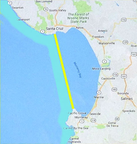
Although Monterey
Bay is quite different in shape than San Francisco Bay, legally it is a
"closed bay." The U.S. Supreme Court determined in U.S. v. California
(1965) 381 US 139, 14 L.Ed.2d 296, that Monterey Bay was a "closed bay"
under international law. Thus the State of California had jurisdiction
well beyond the expected 3-mile limit — not just 3 miles off Moss
Landing — to about 12 miles seaward. The narrowest point is a
line between Pt. Pinos in Pacific Grove and Lighthouse Pt. in Santa
Cruz (the yellow line on the map at left). Then the 3-mile-limit
extends 3 nmi west from the narrowest point of the Bay (shown in the
paler green-blue on the map).
In fact, the California Supreme Court case of Ocean Indus. v. Superior Court of California, in & for Santa Cruz County
(1927) 200 Cal. 235, 252 P. 722, held that the county lines continued
across all of Monterey Bay so that the county courts had jurisdiction
over claims of illegal fishing anywhere in the Bay. |
|
In
that case, fishermen fishing for sardines and anchoring 3.5 miles off
the coastline in the Monterey Bay claimed they could not be prosecuted
for violation of fishing limits, etc., because the State and the County
had no jurisdiction. In a long opinion, citing much international law
and going back to the Treaty of Hildalgo, the court held that both
the State and the County had jurisdiction over the 'closed bay' between
Santa Cruz and Pt. Pinos, plus 3 miles westward into the Pacific Ocean.
Thus where Gov't Code sect 23144 read, in defining Monterey County:
"Beginning in the Pacific Ocean, at the southwest corner of Santa Cruz;
thence east to the mouth of Pajaro River, on the Bay of Monterey;
thence up said stream....", the 1927 California Supreme Court case says
that spot "in the Pacific Ocean" is 3 miles west of the line between
the headlands that enclose Monterey Bay.
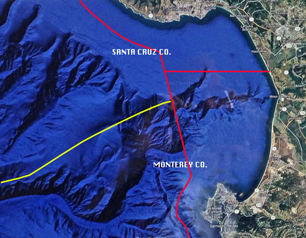
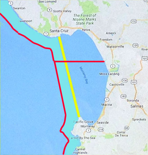
This
map (left) shows the official county lines across Monterey Bay and to 3
nmi west of the narrowest point of the Bay (footnote 3). The east-west
line runs to the mouth of the Pajaro River as it was at the time the
statute was enacted. [Today that point is a few hundred yards south of
the rip-rap edge of the Pajaro Dunes colony. It does not matter where
the actual river mouth is at any particular time, since the river mouth
changes seasonally with water flow.] |
|
When
we combine the formal county lines set out by law and interpreted by
the Supreme Court within Monterey Bay — the red lines on the map
below — and then add the principle of "nearest point of land"
when seaward of those official boundaries — the yellow line below
— we have a complex situation. Fortunately, obtaining a lat-long
or GPS location is easily applied against this map of county lines at
sea. |
|
A
close-up of the map on Radamaker's website (right) illustrates how
these lines 'smooth out' as one pulls back from the details.
If
you look closely on "google maps" you can see a slight difference in
background shading where the official State and county boundaries cross
the Bay some 3 miles west of the narrowest part of the Bay and west of
the Monterey Peninsula. This shading even shows up on eBird maps.
|
|
|
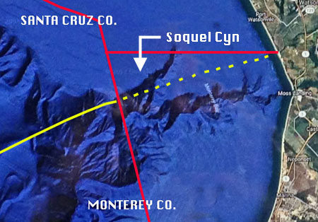
Unfortunately, eBird maps still apply the "nearest point of land" protocol inside
Monterey Bay — more or less as shown by the yellow dotted line on
the map at above left, which shows Soquel Canyon. This creates a
triangle in Monterey Bay, formed by the official boundary in red and
the "nearest point of land" in dots of yellow, that includes most of
Soquel Canyon. This location is often visited on pelagic trips but
eBird will mistakenly assign birds within that triangle to Santa Cruz
Co., when they are actually within the formal boundaries of Monterey
County. Except for this problem, eBird works well elsewhere in Monterey
Bay and works just fine far offshore. |
|
Footnotes:
- Treaties
between nations can change an offshore boundary to a different spot
than "nearest point of land." Further, there have been cases when
equitable analysis has moved an offshore line under rules of
international law (e.g., North Sea Continental Shelf cases before the
Hague International Court or the Anglo-French arbitration of 1977).
These cases are rare but have been applied to determine the division of
monies for exploitation of seabed resources off the Atlantic states;
see Charney, 1981, "The delimitation of lateral seaward boundaries
between states in a domestic context," Am. Journal Intern. Law 75: 28-68. None of these concepts affect those of us in coastal central California.
- 1 nautical mile = 1.15078 statute mile. Thus the 200 nmi limit is just over 230 statute miles.
- Earlier
verisions of this web site were before I discovered the 1927 Supreme
Court case and misinterpreted the county lines within Monterey Bay. I
apologize for that error.
|
|
|
|