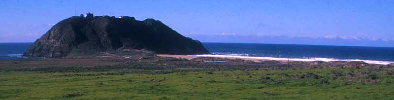
Local Monterey County birders consider the Big Sur River mouth and
Pt. Sur a wonderland for birds, and in their heads they have combined two
state parks (Andrew Molera State Park & the Pt. Sur Lighthouse State
History Park), plus intervening private land (El Sur Ranch) into a huge
birding area known as the "Molera/Pt. Sur listing area," or "the Molera
list" for short. The landmark Pt. Sur (above) anchors the north
end of the zone while Andrew Molera State Park encompasses the southern
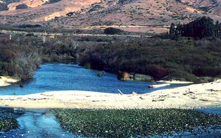
end. Andrew Molera State Park has a substantial wilderness in the little-visited
"back country" but its primary feature is the mouth of the Big Sur River
(below). Birders also include in the zone offshore waters to 12 miles
offshore (U.S. international sovereignty boundary). Access to Pt. Sur,
the offshore waters, and El Sur Ranch is extremely limited or infrequent,
but Andrew Molera State Park is open to the public all the time (directions
farther down this page).
The following photos and text provide an overview, but a detailed spot-by-spot discussion of where to bird at Andrew Molera State Park is on-line on Craig Hohenberger's web site; it features a "Birding Molera" article written by Craig and Jeff Davis, plus a detailed park map, photos, and more.
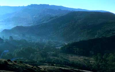 Upstream
from the mouth the Big Sur River curves to the south and then winds into
the Santa Lucia Mountains where almost all of its watershed is protected
within the Ventana Wilderness of the Los Padres National Forest. This view
(right) looks south up the river just as the morning fog is burning off.
In the front left is a heavy riparian forest of cottonwoods, willows and
sycamores. The Big Sur Ornithology Lab is located within this riparian
forest, and their nets are mostly within the riparian zone. [The Big Sur
Ornithology Lab ("BSOL") is operated by the non-profit Ventana Wilderness
Sanctuary; see the VWS website
for many more details on BSOL and their other environmental activities,
including California Condor and Bald Eagle recovery programs.] Upstream
of BSOL the Big Sur River flows through redwood groves in the southern
end of Andrew Molera State Park and then through the popular Pfeiffer-Big
Sur State Park. [Birders do not consider Pfeiffer-Big Sur to be part of
the "Molera list" area.] To the east (out the left side of this photo)
there is much rugged chaparral, grassland, and coniferous wilderness within
Andrew Molera SP, including the upper end of the south fork of the Little
Sur River.
Upstream
from the mouth the Big Sur River curves to the south and then winds into
the Santa Lucia Mountains where almost all of its watershed is protected
within the Ventana Wilderness of the Los Padres National Forest. This view
(right) looks south up the river just as the morning fog is burning off.
In the front left is a heavy riparian forest of cottonwoods, willows and
sycamores. The Big Sur Ornithology Lab is located within this riparian
forest, and their nets are mostly within the riparian zone. [The Big Sur
Ornithology Lab ("BSOL") is operated by the non-profit Ventana Wilderness
Sanctuary; see the VWS website
for many more details on BSOL and their other environmental activities,
including California Condor and Bald Eagle recovery programs.] Upstream
of BSOL the Big Sur River flows through redwood groves in the southern
end of Andrew Molera State Park and then through the popular Pfeiffer-Big
Sur State Park. [Birders do not consider Pfeiffer-Big Sur to be part of
the "Molera list" area.] To the east (out the left side of this photo)
there is much rugged chaparral, grassland, and coniferous wilderness within
Andrew Molera SP, including the upper end of the south fork of the Little
Sur River.
The maps below show the general outline of the "Molera/Pt. Sur" listing area: Andrew Molera State Park, the Pt. Sur reservation and lighthouse, the connecting private land between, and offshore waters to 12 nautical miles.
DIRECTIONS: The primary public access is at Andrew Molera State Park on Highway 1 approximately 21 miles south of Carmel (21.2 miles from the intersection of Rio Road & Hwy 1). Enroute south from Carmel you'll pass
 Except during flood stage in winter, a wooden bridge leads from the main
parking lot to the south side and then west to the beach (~1 mile walk),
and there is also another bridge from in front of the BSOL lab to the south
side of the river. All these trails connect. There is a walk-in campground
(half-mile walk from main parking lot; another fee for camping) along the
main trail to the river mouth along the north bank (also ~1 mile walk).
An alternative access point to the main trail along the north bank is a
wide dirt pull-out on the west side of Hwy 1 about a quarter-mile north
of the main State Park entrance. Here a stile through the fence begins
a wide path to the eucalptyus grove that surrounds the Cooper Cabin (a
historic cabin of an early pioneer that has been rebuilt). Here this trail
joins the main north bank trail. The walk-in campground is a just few hundred
yards upstream (to the left) and the Molera Pt. headlands are about a quarter-mile
to the west (right). There is a green port-a-potty on the left side of
the trail just at the entrance to the "headlands patch" which is a large
expanse of willows at the river mouth along the north bank.
Except during flood stage in winter, a wooden bridge leads from the main
parking lot to the south side and then west to the beach (~1 mile walk),
and there is also another bridge from in front of the BSOL lab to the south
side of the river. All these trails connect. There is a walk-in campground
(half-mile walk from main parking lot; another fee for camping) along the
main trail to the river mouth along the north bank (also ~1 mile walk).
An alternative access point to the main trail along the north bank is a
wide dirt pull-out on the west side of Hwy 1 about a quarter-mile north
of the main State Park entrance. Here a stile through the fence begins
a wide path to the eucalptyus grove that surrounds the Cooper Cabin (a
historic cabin of an early pioneer that has been rebuilt). Here this trail
joins the main north bank trail. The walk-in campground is a just few hundred
yards upstream (to the left) and the Molera Pt. headlands are about a quarter-mile
to the west (right). There is a green port-a-potty on the left side of
the trail just at the entrance to the "headlands patch" which is a large
expanse of willows at the river mouth along the north bank.
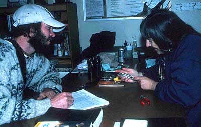
Primary birding spots: there are so many places to check that one rarely gets to all in a single day. A lot depends on time of year and the weather. Weather is a huge factor here -- often calm & lovely in the morning but very windy by mid-day. Many afternoons seem too windy to bother birding. Fog can also be a problem (esp. in summer) when the entire river mouth can be socked in (see the photo at the bottom of this page). At other times the fog bank will be sitting just offshore. The more important sites within Andrew Molera SP are:
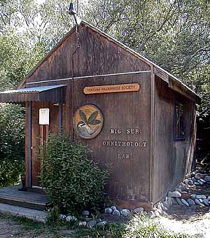
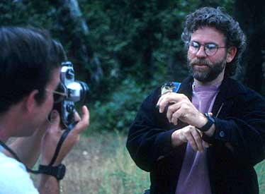
 Small
landbirds are the primary species banded; BSOL processed over 50,000 birds
of 160 species in its first 8 years. Each netted bird is extracted from
one of the 20+ nets & brought to the lab for processing. There it is
measured, weighed, aged & sexed (if possible) and checked for details
of molt and breeding activity. In this photo (right) volunteer Rita Carratello
measures a Hutton's Vireo while BSOL Associate Coordinator Jason Scott
takes the vital statistics. The BSOL intern program is invaluable in operating
the lab, and provides the interns (most of them recent college graduates
from all over the country) with important field experience as they prepare
for careers in biological or environmental fields. Volunteers are also
vital to the lab's work. BSOL not only operates the lab as a MAPS monitoring
station for Neotropical migrants, but oversees research on life history
& ecology of resident species such as a color-banded Chestnut-backed
Chickadee project underway. BSOL staff, interns, and volunteers also run
ancillary net sites at Carmel R. mouth, undertake point counts on numerous
transects, and have contracted for environmental research work countywide.
Again, see the VWS website for
much more information.
Small
landbirds are the primary species banded; BSOL processed over 50,000 birds
of 160 species in its first 8 years. Each netted bird is extracted from
one of the 20+ nets & brought to the lab for processing. There it is
measured, weighed, aged & sexed (if possible) and checked for details
of molt and breeding activity. In this photo (right) volunteer Rita Carratello
measures a Hutton's Vireo while BSOL Associate Coordinator Jason Scott
takes the vital statistics. The BSOL intern program is invaluable in operating
the lab, and provides the interns (most of them recent college graduates
from all over the country) with important field experience as they prepare
for careers in biological or environmental fields. Volunteers are also
vital to the lab's work. BSOL not only operates the lab as a MAPS monitoring
station for Neotropical migrants, but oversees research on life history
& ecology of resident species such as a color-banded Chestnut-backed
Chickadee project underway. BSOL staff, interns, and volunteers also run
ancillary net sites at Carmel R. mouth, undertake point counts on numerous
transects, and have contracted for environmental research work countywide.
Again, see the VWS website for
much more information.
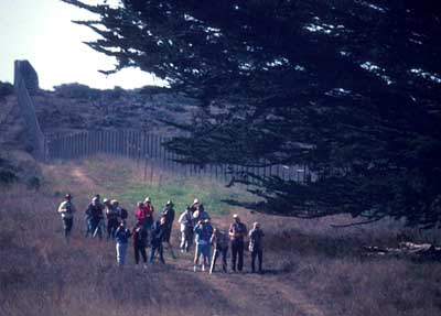
OUTLYING SITES: The foregoing discussion has focused almost entirely on birding sites within Andrew Molera State Park, and especially those around the Big Sur R. mouth. Indeed, birders tend to use the words "Andrew Molera State Park" and "Big Sur River mouth" interchangeably. Many hot-lines talk about "Andrew Molera" for bird sightings, but in publications I always use "Big Sur R. mouth" (a) because it is a specific geographic locale not subject to name change on the whim of politicians (who can always change the names of parks) and (b) because it is more specific (meaning the river mouth, a couple miles of riparian vegetation, and/or the adjacent mesa). Andrew Molera State Park is a huge 4800 acre park and the vast majority of it is east of Highway 1. This area can be accessed from a trail that goes under Highway 1 near the entrance road and then zig-zags up the steep slope through grasslands, then chaparral, and finally rocky areas on the ridge. It is a hot, steep trail that very few birders undertake, but on the ridge above are some species (e.g., Rock & Canyon Wren, several records of Burrowing Owl) that very rarely occur along the river below.
There are also trails into the wild back-country of Andrew Molera SP from Old Coast Road, the dirt road that takes off inland just opposite the entrance to the State Park (this road is impassable during winter rains). All these areas are within the "Molera/Pt. Sur" listing area (at least all the land within the state park, and all of Old Coast Road until it crosses the first major ridge and goes into the next watershed).
Pt. Sur itself is a great spot for sea-watching but access is limited to the park tours mentioned above, or the occasional surveys by teams on the Big Sur Christmas Bird Count. Vernal pools at the base of Pt. Sur can be partially scoped from the edge of Highway 1, or have been occasionally checked by BSOL staff with permits. Several great vagrants have been found (e.g., Tricolored Heron, Least Bittern). The private El Sur Ranch and other adjacent private land is not open to the public but BSOL researchers occasionally obtain permits, and these surveys -- plus those at the private housing near Pt. Sur that is also off-limits to the public -- have produced a wide variety of other rarities (e.g., MTY's first Common Grackle during the few years when BSOL interns resided there).
Offshore waters (to 12 n.mi from Pt. Sur but south of those areas closer to Hurricane Pt.) have been visited on organized pelagic trips the last few years, generally in October. Most common pelagic species have now been recorded within this zone, plus some rarities (e.g., Flesh-footed Shearwater, Thick-billed Murre).
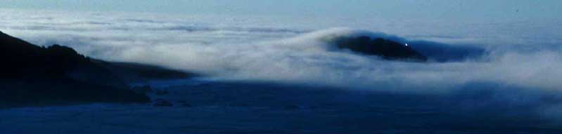
A complete Molera/Pt. Sur list for the entire area is on-line HERE;Bottom photo: Pt. Sur in fog, a common summertime occurrence, looking south from near Hurricane Pt. (the lighthouse beacon is visible). All photos on this page are © 2000 Don Roberson (except the BSOL building shot by Jason Scott, used with permission); all rights reserved.A photo gallery of Big Sur R. mouth & Pt. Sur vagrants is on-line HERE; and
A short history of Molera birding and a photo gallery of the Molera/Pt. Sur 300 CLUB is on-line HERE