 A
long time ago, sometime in the 1980s, John Sterling challenged his local
birding friends to meet the challenge of finding at least 100 species of
birds in each of California's 58 counties. Those who took up the challenge
back then were mostly students at Humboldt State University or their birding
friends. The core group called themselves "the vagrants." County listing
was not a new idea. Several birders in the 1970s had actively birded in
all of the State's counties, including Dick Erickson, Steve Laymon, John
Luther, and Rich Stallcup. But Sterling's group was the first semi-organized
broadscale county listing endeavor. A
long time ago, sometime in the 1980s, John Sterling challenged his local
birding friends to meet the challenge of finding at least 100 species of
birds in each of California's 58 counties. Those who took up the challenge
back then were mostly students at Humboldt State University or their birding
friends. The core group called themselves "the vagrants." County listing
was not a new idea. Several birders in the 1970s had actively birded in
all of the State's counties, including Dick Erickson, Steve Laymon, John
Luther, and Rich Stallcup. But Sterling's group was the first semi-organized
broadscale county listing endeavor.
In the 1990s, Sterling broadened his challenge to a wider group of California
birders by providing a central hub for county listing efforts. He compiled
complete county lists as best he could, he created spreadsheets of lists
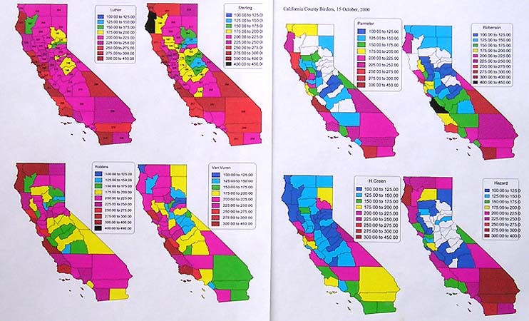
and listers, and he started providing colored maps to participants. One
had to reach a minimum of 100 in a county to get a color — the first color
was a cool purple. After that, the colors changed at each 25 bird plateau:
blue for 125, green for 150, yellow for 175, red for 200. After that cross-hatching
replaced colors at 25/bird increments until 250 (orange-red), at which
times increments grew larger (nothing between 300-400) and 400 was black.
In other words, one started cool, warmer up with more species, got really
hot at 200/species and beyond, and burned to a crisp over 400. [Only a
handful of birders have over 400 in any county; most are in San Diego,
Monterey, Marin, or Humboldt counties but almost every coastal county has
at least one 400 county-lister.]. A set of maps of 8 observers, as of 15
October 2000, is below. |
|
| The maps of the 4 leaders at the time (Oct 2000) are the 4 left-hand
set; the 4 on the right are various others with fewer county birders. The
top two maps (upper left) show John Luther and John Sterling — Luther was
then nearing 200 in every county (and would be the first to break that
barrier within a couple of years).
In winter 1996-1997, I spent hours digging through my field notes to
create a spreadsheet of what I had seen in my California state birding
since the late 1960s. I have decent notes for most birding trips, although
sometimes very common birds were not mentioned. My rule was that it had
to be in my notes to go on my spreadsheet, and some birds that I surely
must have seen (e.g., Red-tailed Hawk in Modoc Co.) are still not on my
list because I never wrote them down. My wife, Rita Carratello, first got
interested when she saw the brightly colored maps. She's a teacher, and
called this a "mystery motivator" [you never know what will motivate some
people]. Our first birding trip aimed at this type of "county listing"
was in July 1997, to El Dorado, Alpine, and Amador.
My own map from Oct 2000 is upper right (above). By the time of this
map, Rita & I had done a northern California swing through Lassen,
Modoc, and Siskiyou, and a fair bit of effort in some foothill counties.
Mostly in shows however, that I had birded a lot in the California deserts
and coast in the 1970s (searching for State birds and rarities), and that
there were still ten counties in which I had not reached 100. It became
a mild goal of both Rita and me to fill in our maps completely with at
least 100 in each county.
Since the turn of the 21st century, interest in county birding has blossomed
substantially. Many folks now play Sterling's 'county game.' Steve Rovell
established a "county listers" (now "county
birders") chat line to quickly spread information about good sites
in obscure counties. Joe
Morlan's web site provided links, statistics, and information on each
county. I recall telling Jim Lomax about the game in April 1997,
while we were waiting for a Common Black-Hawk to appear near the north
end of the Salton Sea (it never did), and he thought that might be an interesting
thing to do when he retired in the then near-future. He has since become
a maniac at the game and is about #3 in the game right now. Rita and I
continued to do the occasional county listing trip, usually in mid-summer
and winter, as we prefer to remain local in Monterey County during spring
and fall migration (where we are both members of the Monterey 400 club). |
|
| In any event, the goal of 100 in each California county remained a
small goal in my birding, much less important than seeing new State birds,
or new Monterey County birds, or even new World birds. My recent focus
has been on birding the world and finding representatives of each of the
~224 bird families. I also wanted to get to 5000 birds in the world — half
of the earth's birds — and reached
that goal in July 2005.
Yet the 100-in-each-county remained something else to accomplish, and
it did require one to visit many new places in California. For me, that
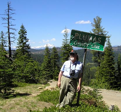
goal was reached on 21 June 2006, in this county (right) . . . . |
 |
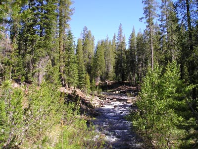 |
It was at this spot (left) — along Road 10 in Plumas County, heading
toward Echo Lake, at about 5800' elevation in nice montane forests . .
. |
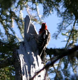
| . . And with this bird (right): Red-breasted Sapsucker. This particular
sapsucker proved to be exactly #100 in my 58th California county. [It flew
a second later, so this is a lucky shot.] |
|
|
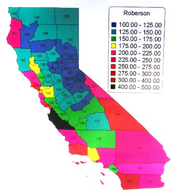 So
my map finally is all colored in and looks like this (left). At least 26
others had previously accomplished this goal. Many are now working toward
125 or 150 in each county [Steve Glover reached the 150 level not long
ago and captioned his posting "Green, Glorious Green!"] or more. John Luther
has over 200 in every county and John Sterling will soon break that barrier
as well. But the game is really geared to those who live close to the many
small Gold Rush counties in the Sierran foothills. Sacramento, Stockton,
or east S.F. Bay are good places to live for this type of county birding.
It is really difficult for someone living in southern California to work
on all the counties surrounding the Sacramento Valley, while, in contrast,
most birders can hit 100 in most southern California counties in a day
at any season (especially the coastal ones). Indeed, coastal counties get
rather little focus in this game — which is partly what makes the game
attractive to some birders. For years, coastal counties have gotten all
the glory because they have the vast majority of vagrants. This game flips
that focus. It was a bit of a struggle for those of us living in coastal
Monterey county, since it is 8+ hours drive to many of the northern tier
counties, and rising petrol prices don't help. So
my map finally is all colored in and looks like this (left). At least 26
others had previously accomplished this goal. Many are now working toward
125 or 150 in each county [Steve Glover reached the 150 level not long
ago and captioned his posting "Green, Glorious Green!"] or more. John Luther
has over 200 in every county and John Sterling will soon break that barrier
as well. But the game is really geared to those who live close to the many
small Gold Rush counties in the Sierran foothills. Sacramento, Stockton,
or east S.F. Bay are good places to live for this type of county birding.
It is really difficult for someone living in southern California to work
on all the counties surrounding the Sacramento Valley, while, in contrast,
most birders can hit 100 in most southern California counties in a day
at any season (especially the coastal ones). Indeed, coastal counties get
rather little focus in this game — which is partly what makes the game
attractive to some birders. For years, coastal counties have gotten all
the glory because they have the vast majority of vagrants. This game flips
that focus. It was a bit of a struggle for those of us living in coastal
Monterey county, since it is 8+ hours drive to many of the northern tier
counties, and rising petrol prices don't help.
Some years back, Luke Cole did a hilarious analysis of everyone's map,
finding oddities and eccentricities galore. I was credited with "the most
colorful map" in that I had every possible color and cross-hatching possibility
shown on my map. I rather like that title, and my goal is to maintain it.
I have no desire to upgrade all the remote mountain counties to blue or
green or yellow. I am happy to have a smattering of color across the State.
I would like to upgrade a few things, such as reach 300 in Marin (currently
295) or 300 in Inyo (currently 289). And I'll keep county birding in the
lesser known counties until Rita also colors in her map (she's just four
counties away).
I prefer to continue to focus on Monterey County, and to look for rarities
and pelagics, without overlooking just how much fun it is to visit new
places and see new things. This silly game has provided me an opportunity
to learn much about the distribution of California birds, and to enjoy
many spectacular places that I would have otherwise missed. But thanks
to John Sterling and the merry men and women of "county birders" chat line,
I've piled up many good memories. Some of them I share photographically
in my "California
counties" on-line project [a gallery aimed at personally photographing
several birds in every county.] Many thanks to all!
|
| All photos & text © 2006 Don Roberson; all rights
reserved. |
TOP
TO CALIFORNIA
COUNTIES PORTAL PAGE
TO HOME PAGE
TO CREAGRUS
CALIFORNIA LIST PORTAL PAGE
TO BIRD FAMILIES
OF THE WORLD
|
 A
long time ago, sometime in the 1980s, John Sterling challenged his local
birding friends to meet the challenge of finding at least 100 species of
birds in each of California's 58 counties. Those who took up the challenge
back then were mostly students at Humboldt State University or their birding
friends. The core group called themselves "the vagrants." County listing
was not a new idea. Several birders in the 1970s had actively birded in
all of the State's counties, including Dick Erickson, Steve Laymon, John
Luther, and Rich Stallcup. But Sterling's group was the first semi-organized
broadscale county listing endeavor.
