KEY
BIRDING SPOTS within the Carmel R. mouth area include: KEY
BIRDING SPOTS within the Carmel R. mouth area include:
-
the riparian habitat (willows, cottonwoods, and some live oaks) lining
the dry riverbed both downstream and upstream from the Highway 1 bridge
during fall migration. About halfway to the lagoon is the famous "green
pipe" (photo right) that birders use as a landmark. This area is also good
at other times but there is usually lots of water in the river in winter
and still a fair bit in spring, requiring boots or a willingness to get
wet to bird here. Huge floods in March 1995 washed away the old 1933 bridge,
but the new one was built in just 34 days. A marker on the NW side of the
bridge commemorates this event and provides a parking area; more parking
is just across Hwy 1 in the shopping center. The birder then walks down
under the bridge to the river bed.
-
the ornamental plantings around Carmel mission
-
the marsh stretching below Mission Ranch to the State Beach parking lot,
which hosts rails, bitterns, Swamp Sparrows (in winter) & an occasional
Nelson's Sharp-tailed Sparrow [please note that the Mission Ranch property
itself is limited to customers, and that birders should avoid trespassing
on that private property]
-
the river mouth lagoon for ducks and bathing Brown Pelicans; this lagoon
is variously full or drained depending on when during the winter the river
breaks through to the sea
-
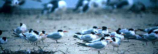
the sandy shores of the river mouth lagoon for flocks of gulls and terns
in season (the photo below shows a flock of Elegant Terns
there in Sep 1991; © D. Roberson)
-
the coastal riparian scrub in and around Cross Hill (a public trail leads
to the top of the hill for great views)
-
the "Odello Lagoon" which is a new arm of the Carmel R. mouth lagoon created
during the revegetation project; it can be viewed nicely with a scope from
Cross Hill [new arms reaching toward Highway 1 have recently been dredged]
-
the sandy beach both north and south of the river mouth
-
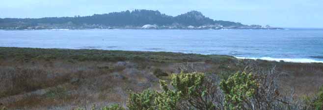
the inner half of Carmel Bay, and
-
the revegetation project south of the river and stretching to the Carmel
Meadow's subdivision. The Odello family gave up their lease following the
1995 floods and the area is now being restored to wetland and riparian
ecosystems. The levee on the south side of the river has been lowered so
there is more opportunity for flooding here instead of flooding the homes
north of the river. In time, this will become fabulous wildlife habitat.
There are plans for a public use hiking trail connecting Rio Park to the
hill with the Portola Cross. For the present, access is limited to local
BSOL banders and a few others with permits. Please do not disturb this
sensitive habitat. Note also that the waste treatment plant on the edge
of the river is entirely off-limits to all birders.
[I an grateful to Glen McGowan and Mary Dellavalle Sanvictores of California
State Parks who contributed information for this page.]
|
| Some local observers keep a "Carmel R. mouth area" list [details of
the boundaries follow] but out-of-town birders will also find much here.
Farther down this page are details highlighting prime localities within
the "Carmel River mouth area."
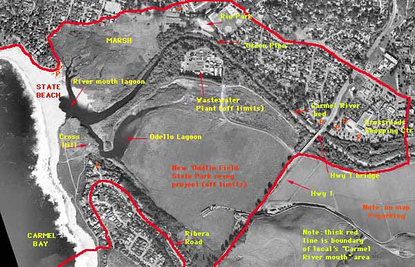
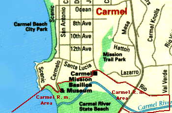 The
Carmel
River mouth listing area is that part of Monterey County centered around
the bed of the Carmel River from Hwy 1 down to the Carmel R. mouth lagoon
and Carmel River State Beach. This initial map (left) shows the general
idea although the southern border along Ribera Road is missing [a more
detailed aerial photograph is below]. The "center" of the area might be
thought of as Cross Hill, where a large cross is erected to mark the spot
where in 1769 the Portola/Crespi expedition erected a cross to alert their
supply boat that they were short on food and had returned to San Diego.
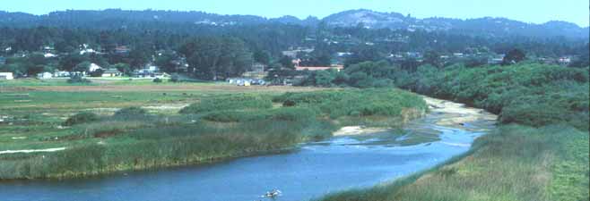
The top photo (© D. Roberson) shows the view east from Cross
Hill, including a part of the river mouth lagoon and marsh, and the sandy
bed of the river beyond. It is the riparian edges to this river bed that
are so attractive in fall migration. In essence, the birding area
includes the Carmel River bed from the inland edge of the Crossroads shopping
center down to the mouth; the entire Carmel River State Beach with its
lagoon, marsh, and sandy shore about halfway down to Monastery Beach; Cross
Hill; and the "Odello fields and Odello lagoon;" and the inner half of
Carmel Bay. In detail, starting from the parking lot of Carmel River
State Beach, the boundary extends eastward along the north edge of the
Carmel R. mouth marsh and through Mission Ranch to Dolores St., curving
around Carmel Mission on Lasuen Dr., to Rio Road. Thence towards Hwy 1
and across it, including the Crossroads Shopping Center, to Val Verde Rd.,
then south to the Carmel River (a flagpole marks the innermost extent of
the riveredge vegetation) to the levee on the south side of the river,
then west to Hwy 1. Highway 1 then forms the boundary south to Ribera Road.
The arc of Ribera Rd. forms the boundary to the end of the road where a
trail drops west to the beach. The area includes all of Carmel R. mouth
beach north of this point to Scenic Drive. The listing area also includes
an arc out into Carmel Bay to the half-way point to Pt. Lobos. From the
State Beach, this means that the large kelp patch off the north end of
the beach is in the listing area, plus some distance beyond, but that birds
in the Bay may be counted only half-way to Pt. Lobos. Many of these details
are shown on this overview photograph (below; © Hammon Jensen, Wallen
& Associates, under contract for the County of Monterey; used with
permission via the auspices of Bill Hill; all rights reserved). The
Carmel
River mouth listing area is that part of Monterey County centered around
the bed of the Carmel River from Hwy 1 down to the Carmel R. mouth lagoon
and Carmel River State Beach. This initial map (left) shows the general
idea although the southern border along Ribera Road is missing [a more
detailed aerial photograph is below]. The "center" of the area might be
thought of as Cross Hill, where a large cross is erected to mark the spot
where in 1769 the Portola/Crespi expedition erected a cross to alert their
supply boat that they were short on food and had returned to San Diego.
The top photo (© D. Roberson) shows the view east from Cross
Hill, including a part of the river mouth lagoon and marsh, and the sandy
bed of the river beyond. It is the riparian edges to this river bed that
are so attractive in fall migration. In essence, the birding area
includes the Carmel River bed from the inland edge of the Crossroads shopping
center down to the mouth; the entire Carmel River State Beach with its
lagoon, marsh, and sandy shore about halfway down to Monastery Beach; Cross
Hill; and the "Odello fields and Odello lagoon;" and the inner half of
Carmel Bay. In detail, starting from the parking lot of Carmel River
State Beach, the boundary extends eastward along the north edge of the
Carmel R. mouth marsh and through Mission Ranch to Dolores St., curving
around Carmel Mission on Lasuen Dr., to Rio Road. Thence towards Hwy 1
and across it, including the Crossroads Shopping Center, to Val Verde Rd.,
then south to the Carmel River (a flagpole marks the innermost extent of
the riveredge vegetation) to the levee on the south side of the river,
then west to Hwy 1. Highway 1 then forms the boundary south to Ribera Road.
The arc of Ribera Rd. forms the boundary to the end of the road where a
trail drops west to the beach. The area includes all of Carmel R. mouth
beach north of this point to Scenic Drive. The listing area also includes
an arc out into Carmel Bay to the half-way point to Pt. Lobos. From the
State Beach, this means that the large kelp patch off the north end of
the beach is in the listing area, plus some distance beyond, but that birds
in the Bay may be counted only half-way to Pt. Lobos. Many of these details
are shown on this overview photograph (below; © Hammon Jensen, Wallen
& Associates, under contract for the County of Monterey; used with
permission via the auspices of Bill Hill; all rights reserved).
|