 The
Pt.
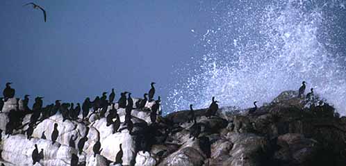
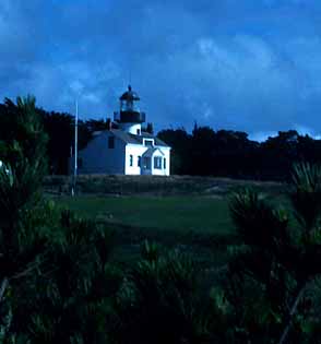
Pinos listing area is that part of Pacific Grove centered around Pt.
Pinos & Crespi Pond at the tip of the Monterey Peninsula (that's Pt.
Pinos in the top photo), stretching "from Ruff to Ruff outside the RR tracks."
Alas, this definition was coined in the late 1970s, and none of these landmarks
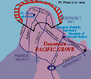
exist today -- so there is detailed explanation below. This map (left)
shows the listing area. Any birds within the heavy lines shown on the map
are countable (e.g., on or over that land), plus any birds
seen from
shore within that area (the orange cross-hatching designates offshore
areas which may be scoped to the limits of one's optics; however, birds
on or over the ocean in this area must be seen from shore within the defined
area -- birds observed from boats just off the Point do not count in the
Pt. Pinos listing area unless that bird is actually sitting on or flying
over the land. As of 1 Oct 2004, the total Pt. Pinos area list was: The
Pt.
Pinos listing area is that part of Pacific Grove centered around Pt.
Pinos & Crespi Pond at the tip of the Monterey Peninsula (that's Pt.
Pinos in the top photo), stretching "from Ruff to Ruff outside the RR tracks."
Alas, this definition was coined in the late 1970s, and none of these landmarks
exist today -- so there is detailed explanation below. This map (left)
shows the listing area. Any birds within the heavy lines shown on the map
are countable (e.g., on or over that land), plus any birds
seen from
shore within that area (the orange cross-hatching designates offshore
areas which may be scoped to the limits of one's optics; however, birds
on or over the ocean in this area must be seen from shore within the defined
area -- birds observed from boats just off the Point do not count in the
Pt. Pinos listing area unless that bird is actually sitting on or flying
over the land. As of 1 Oct 2004, the total Pt. Pinos area list was:
If you find a new species for the Pt. Pinos area, or any especially rare species there, please:
The "outside the railroad tracks" designation refers to the former bed of a rail line which once ran from Monterey to Pebble Beach; there were still RR tracks there in the 1970s. Today this bed is public open space and known as the Monterey Peninsula hiking trail. The line is a little obscure through the front nine of the Pacific Grove Municipal Golf Course, but is very apparent as it crosses the back of the P.G. cemetery and continues south between Crocker & Grove Acre. The listing area is "outside" (or west and north) of the arc formed by that old railroad bed [unfortunately for me personally, my yard on Grove Acre is just outside the Pt. Pinos area]. |
KEY BIRDING SPOTS within the Pt. Pinos area include:
 |
 |